|
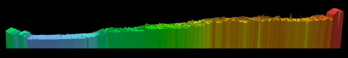
One of the discoveries made with MOLA made is that the surface of Mars slopes upward
going from the North Pole to the South Pole. The image below is a pole-to-pole
view of Martian topography from the first MOLA global topographic model
[Smith et al., Science, 1999].
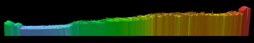
This slice runs from the north pole (left)
to the south pole (right) along the 0° longitude line. It shows
the pole-to-pole slope of 0.036°, such that the south pole has a
higher elevation than the north pole by ~6 km. This global-scale slope was
likely present for most of Mars' history and controlled the surface and
subsurface transport of water indicated by images of outflow channels and
valley networks. The regional high (in orange, to the right) in mid-southern
hemisphere latitudes corresponds to the western edge of the topographic
annulus that encircles the massive Hellas impact basin. In the figure
warm colors correspond to high elevations and cold colors
correspond to low elevations.
Note the exceedingly flat northern hemisphere in blue. (Image credit: MOLA
Science Team).
But this pole-to-pole slope isn't the only factor in the flow of water on
Mars. The formation of the massive volcanic rise, called the Tharis rise,
may have affected the early climate and flow of water on the Martian surface.
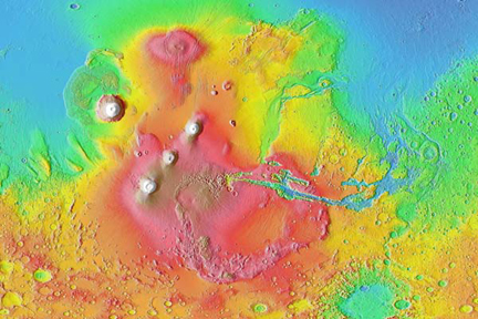
The Tharsis Region
Tharsis is a BIG load on the surface of Mars and when it was emplaced it
deformed the whole surface of the planet, just like what would happen if if
a beach ball was punched. By developing models, the MOLA Team showed that
loading of Mars by Tharsis explains much of the global shape and
long-wavelength gravity field of the planet. Loading by Tharsis also
explains a ring of negative gravity anomalies and a topographic trough
around Tharsis, as well as gravity-anomaly and topographic highs centered
in the Arabia Terra region and extending northward toward the Utopia basin.
The Team showed that the Tharsis-induced trough and antipodal high were largely
in place by the end of the Noachian Epoch, the earliest stratigraphic epoch
in Martian history (about 4 billion years ago).
Tilts on the planet caused by Tharsis loading also exerted control on the
location and orientation of valley networks. The MOLA Team determined this
by showing that most valley networks have azimuths that on average match
the tilt induced by the combination of the response to Tharsis loading and
the pole-to-pole slope of topography.
Why this is important? The release of carbon dioxide and water
accompanying the emplacement of approximately 300 million cubic kilometers
of Tharsis magmas (about 10,000 Mauna Loas!) may have sustained a warmer
climate than at present, enabling the formation of ancient valley networks
and causing massive erosion. This is because the magmas released enough CO
to produce a 1.5-bar atmosphere (producing a Greenhouse effect) and enough
water to produce a global layer 120-m deep. This analysis shows that
Tharsis may be the factor responsible for Mars's early wetter, warmer
climate.
Links & Resources
Text and Figures on the
Ancient Geodynamics and Global-scale Hydrology on Mars.
See also
Ancient Geodynamics and Global-Scale Hydrology on Mars,
Science, Vol 291, March 30, 2001.
More information about the
pole-to-pole
slope.
|